Presenting digital information in an instantly understandable way is the critical challenge facing physical security practitioners. Especially in large facilities, we see a growing mountain of accessible data: recorded video from hundreds or thousands of cameras, access logs, alerts from analytics systems, etc. Success or failure of a security department is determined by how quickly and accurately it understands and reacts to that information. Can the modern security system bridge the gap between the digital world and the real situation on the ground?
We have seen demand for 3D technology in the security industry continue to grow, fuelled by faster networks and higher-quality cameras. While these factors have real potential to improve the effectiveness of every security department, this potential can only be realized if the data is actionable. 3D technologies can accomplish it.
The biggest step to linking the digital data with the real world is to answer the question of "Where?" Where is Camera 8? Where is he walking to? Where is the fire alarm that was pulled? Applying a 3D map of a particular location or site provides a new visual dimension to what a command station operator can see, and what he or she might be missing. This integrated understanding is the key to successfully creating a multiple-layer security system that incorporates technologies such as sensors, access control and cameras.
3D graphics - a field not long ago reserved for training astronauts and fighter pilots - has rapidly proven itself as a tool for security departments to use on a day-to-day basis. But what real benefits can be derived from the use of 3D maps instead of regular 2D plans? What makes a 3D map useful instead of mere eye-candy?
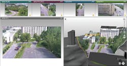
A good 3D map provides an intuitive visual framework for security; for example, a security guard can simply fly through the virtualized facility and watch a fusion of all videos in their real locations, instead of memorizing the locations of hundreds of cameras. Fuse this together with the locations of emergency exits and access points, and 3D starts to provide the big picture, so that the small picture (every individual video stream, sensor, etc.) now makes sense. The digital world begins to accurately reflect the real one.
The benefits of 3D are tangible and measurable for security directors, consultants, and integrators. A prime example of this is for surveillance planning. Adding new surveillance cameras to a facility is a complicated process, involving floor plans, photos and much back and forth between the site and the office. By using highly realistic 3D maps, integrators and consultants require fewer site visits - a demonstrable time and cost saving. Also, since the 3D software is intuitively visual, consultants are able to present convincing plans to security directors and financial managers. It becomes simple to show how a planned upgrade remedies serious gaps in coverage, justifying the additional budget required to secure a facility.
Cities today, such as Chicago and New York, are investing heavily in unifying public safety networks across vast areas, encompassing many layers of security and geographic information. To do this, these cities establish close ties between public security/public safety and mapping departments, because security data alone on such a large scale is not understandable or actionable. 3D-based products provide the technology framework that enables these departments to work side-by-side, deriving value from each other's expertise. Existing security assets, such as video recording systems and cameras, have their value drastically augmented with existing mapping data.
With Omnipresence 3D from Feeling Software, the goal has been to make security information actionable. One feature called Fast Track enables a security operator to look at one video, point with the mouse in any direction inside the video, as if to say "I want to see over there," and the camera with a view of the targeted area comes up instantly. PTZs in the area are automatically redirected to cover the nearby hallways to virtually guarantee that the suspect will never get out of view.
Whether it is used for live tracking and situational awareness in an airport, or to cut hours off an investigation on a university campus, 3D graphics can make existing video interactive and actionable for the security operator.
In the years to come, more and more large scale facilities will encounter the problem of "information overload," where adding new digital sensors makes it increasingly complex to relate the information on the screen with what's happening on the ground. Innovative technology such as 3D mapping will continue to provide links between the digital world and the real one.
