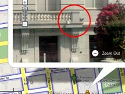
If your facility is in San Francisco, Denver, Miami, Las Vegas or New York, potential terrorists could be looking over your facility right now, trying to see where your doors are located, where parking lots abut the building.
Perhaps strangest of all, they don't even have to come to your facility's street, posed as tourists or sitting in a van with cameras. Leading search engine company Google, instead, has allowed them to do this from any computer, in any home or Internet caf‚ around the world. Google's new Street View tool links panoramic high-resolution photos taken from cars on public streets to its popular mapping service, Google Maps.
Auspiciously, these images would be helpful to locate a driving address and see the actual address you're trying to find, but with high-resolution detail, you can practically make out the license plates of cars parked on the streets (you can see the California-registered red, 2-door Honda Civic parked on Goodlett Street in downtown San Francisco and easily read the license plate. In some instances, people faces are recognizable, but in a more questionable element, the Street View can pinpoint building details. In a test on the streets of San Francisco, I was able to locate San Francisco's City Hall and look to see where the outside surveillance cameras might be.
The images are surprisingly clear, though sun spots block out certain areas. Google apparently sent out teams with cameras in cars on the streets of those five major U.S. cities to take a series of photos that could be stitched together to give a panoramic feel. There's no legal foul to posting these photos on the Internet; having been taken from a public place, they don't capture any more detail than what anyone could see from just walking down the street. A drag-and-zoom function gives you control like a PTZ camera would, though the images are static.
To access the system yourself, visit maps.google.com or click on the Maps link atop Google's home page. Then, once in one of the five current cities, click the "Street View" link atop
Google's Stephen Chau, product manager for Google Maps and Google Earth, says in its "Lat Long Blog", the blog where he updates news on Google's mapping tools, that the service will be rolled out to more cities "in the near future."
From a security perspective, it's hard to say whether this might have much of an impact on your operations. Nonetheless, it is clear that people taking photos of non-tourist types of facilities (water plants, government buildings, etc.) do tend to raise a red flag when spotted by security staff members. A number of security departments tend to watch for cars parked for an inordinate amount of time outside their facilities to see if those people are "casing the joint", so to speak. But with the ability to do low-impact surveillance of your facilities from afar, potential perpetrators might be able to use public data in these photos, such as where the delivery trucks park, or where the side-entrances to your facility are.
If you find your facility and see something objectionable, Google does have a method for reporting this. Click on the "help" tab while viewing a location and use the "report inappropriate image" link you find there.
In the Forums:
Share your thoughts on whether this Google service (it's also available from some of the other online powerhouses, including Microsoft) creates security problems from a facility protection point of view:


