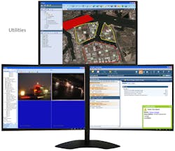
NICE Systems and geographical information system (GIS) software provider Esri have partnered to enhance NICE's Situator situation management system with Esri's GIS capabilities. The integrated solution combines Situator's data fusion, analysis and automated response capabilities with spatial analysis, data management, and GIS mapping, to improve situational awareness and real-time situation management. The system correlates data from diverse security, safety and operational systems, alerting operators in real-time to incidents that require attention. All of the relevant information is then overlaid on an intuitive GIS interface.
Request More Information
Request More Information
Latest in Integrated Security Management Systems & PSIM
Latest in Integrated Security Management Systems & PSIM


