Las Vegas – In a day and age where an ever-increasing number of surveillance cameras and other security sensors are brought online every day, end-users are tasked with the challenge of finding the most efficient way possible to integrate all of this data. While enterprise-class video management systems (VMS) and physical security information management (PSIM) software solutions have done a tremendous job of providing security executives and public safety officials with a comprehensive view of their security operations, there are a still a number of data sets can be of tremendous benefit to these systems but prove difficult to incorporate.
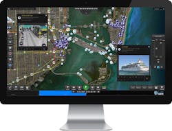
Enter Live Earth, a real-time mapping platform that enables users to integrate a number of disparate sources of information into an easy to navigate user interface.
I had a chance to catch up with Live Earth CEO Jeff Carpenter at ISC West in Las Vegas to discuss what makes their solution so unique to the marketplace and why they decided to exhibit at the show for the first time this week.
Griffin: What’s your background in the security industry and how did you come to develop this unique software offering?
Carpenter: Our team has spent a number of years developing customer software solutions for the U.S. military. We specialized in quick reaction, prototype, and operational systems with a focus on data visualization, human factors and user interface design. Our products were built for analysts and operators in the U.S. Army, U.S. Navy, U.S. Air Force, Special Operations Forces, DARPA, and other federal and intelligence community organizations.
We soon realized that our advanced mapping technology could solve problems faced by law enforcement and other public safety customers and had value for numerous applications outside of the military. Live Earth now serves these other industries by tailoring that same, proven military software for their need to quickly understand complex, critical scenarios and act fast to inform decision-makers.
Griffin: What kinds of capabilities does your software provide to security end-users and what differentiates it from similar solutions on the market?
Carpenter: Our software decreases response times for key decision makers by aggregating real-time data from multiple systems onto a single interactive map, creating the world’s most powerful real-time visual operations center. Live Earth comes out of the box with live data feeds from our partners and public sources but it also integrates with your private and proprietary systems to give you an up-to-date holistic view of your city, state or region. But our biggest differentiator is that with Live Earth, you can play that data and rewind it to provide instant incident reconstruction. All of the features taken together provide operations centers with the capability to react quicker and make more informed decisions.
Griffin: How are you able to pull all of these various data points, such as surveillance cameras from various government agencies, into your solution?
Carpenter: Many of the data sources are public. But we’ve also partnered with organizations and government agencies all over the world based on relationships we developed during our years of work in the space.
Griffin: How many different pieces of information can the software layer onto your graphical user interface and can an end-user pick and choose what data they want to see as their needs change?
Carpenter: Live Earth can visualize and animate millions of data points simultaneously from a multitude of different data sources. Our users can show and hide different data sources based on their specific operations or function. Live Earth gives organizations a lot of flexibility to determine what’s most useful and most relevant to what they do.
Griffin: I assume large municipalities and government agencies are one of the primary vertical markets you’re targeting with this solution, but do you foresee any other applications for it?
Carpenter: Live Earth is a generic mapping platform specifically designed for real-time data feeds and time series data visualization. As such, there aren't any real limitations to its applicability. We are exploring uses in IoT, logistics, transportation, smart cities and more.
Griffin: Why did you decide that now was the time to exhibit at ISC West and what are you expecting from having a presence on the show floor?
Carpenter: The powerful capabilities that Live Earth provides bring something new and valuable to the industry that doesn’t yet exist in other solutions. We believe Live Earth will make safety and security agencies quicker and more effective almost immediately. Live Earth will allow them to best leverage the investments they've already made in other technologies by consolidating their critical data onto a single situational awareness display. The flexibility and the ease of deployment also make Live Earth a solution to the problem of siloed data streams that couldn’t be easily integrated previously.
About the Author:
Joel Griffin is the Editor of SecurityInfoWatch.com and a veteran security journalist. You can reach him at [email protected]
About the Author
Joel Griffin
Editor-in-Chief, SecurityInfoWatch.com
Joel Griffin is the Editor-in-Chief of SecurityInfoWatch.com, a business-to-business news website published by Endeavor Business Media that covers all aspects of the physical security industry. Joel has covered the security industry since May 2008 when he first joined the site as assistant editor. Prior to SecurityInfoWatch, Joel worked as a staff reporter for two years at the Newton Citizen, a daily newspaper located in the suburban Atlanta city of Covington, Ga.

