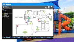
OpenEye Web Services’ (OWS) new cloud-based maps provide visual context and improve response time with user-friendly, interactive maps customizable to your locations.
Maps enable OWS users to view devices, receive alerts, and track a location’s armed status using Google Maps and custom uploaded floorplans. Share and sync maps across authorized teams, creating efficiencies and ensuring they are equipped to act when needed.
Below, we’ll cover the benefits of this new feature in OpenEye Web Services for organizations everywhere.
Improve Situational Awareness Throughout Facilities
Maps in OWS improve situational awareness for businesses by visually showing where events are taking place across locations. This feature animates on any alerts that are associated with the device, including cameras, recorders, access control, intrusion, and environmental sensors.
View alerts as they take place across your locations, systems and devices. Maps enable quick and easy access of the information you need when it matters most by allowing you to click on alert icons to review event details and related video.
Easily Navigate Locations with Google Maps and Unique Floorplans
Gain greater visual context by incorporating Google Maps and connecting multiple floorplans to each location, making it easier to navigate multiple sites and complex facilities.
OWS users can create layouts that reflect their unique security operations, combining maps, camera views, and alerts in a way that aligns with the particular business’ footprint.
Determine System Status at a Glance
Maps enable you to stay aware of system status with clear visual indicators showing whether a location is armed or disarmed.
By knowing the status of your system, you can ensure your location is protected while reducing false alarms during busier hours.
Share Maps Across Teams
Create efficiencies across teams by sharing maps and layouts among authorized users in the OWS Video Player.
With OpenEye Web Services’ collaborative tool set, teams can view the status of locations while ensuring all authorized persons have visibility into critical incidents.
Utilize Cloud-Based Maps in OpenEye Web Services Today
Maps in OWS can help take your video surveillance to the next level by providing an additional layer of visibility into location security and operations while enabling proactive response for diverse situations. The open ecosystem enables alerts for integrated devices to be easily visualized via a connected map, providing more context during events.
Ready to see cloud-based maps in action? Book an OpenEye demo today.
CTA: Book a Demo
CTA Link: https://go.openeye.net/ows-maps

