Tropical Surveillance Across Hawaii’s Archipelago
Deploying several hundred Axis cameras across the state of Hawaii to function in a variety of roles, Hawaiya Technologies, Inc. has completed a five-phase project to assist multiple end users in the surveillance of harbors and sites. A project with discussions dating back to 2003, the state of Hawaii applied for a Homeland Security grant to build a system providing maritime coverage across its six main inhabited islands. Up to that point, there was no coordinated or inter-island surveillance available to any government or privately licensed entities.
An initial simple system of a basic radar, camera and AIS VHF radio was put in place at the small harbor of Kewalo, the port of entry for all foreign flag fishing vessels, to provide surveillance of vessels when no workers or border control staff was on site. Dealing with further issues at additional harbors across the state, it was noted that a larger system could provide important monitoring and management capabilities. Harbors dealt with boats running aground and damaging reefs, illegal dumping of hazardous waste and vessels coming in during off-peak weekend hours without paying docking fees. The vision for this system was to monitor all of these potential sites and retain alarms that could indicate when boats were heading into trouble, with each individual incident being recorded.
As the project progressed into 2006, Hawaiya singled out Axis to supply the cameras for each distinctive build. “At that time, Axis was the only camera [that fit] and it was really the leader in IP-based [video surveillance options],” said Mun-Won Chang, COO and CFO of Hawaiya. “We did a lot of research and it was the most affordable solution. That’s how we came about the Axis cameras. Once we installed the first set, we installed Axis everywhere we went.
Encompassing multiple factions of the Hawaiian government properties, Hawaiya was tasked with building an all-inclusive structure to cover an abundance of entities. They are responsible for keeping watch over the primary harbors and critical infrastructure sites across the state, and also assume responsibilities in other safety-first environments. The Department of Public Safety (DOPS) utilizes their set-ups in both the Sheriff Division and Corrections Division where they use Axis network cameras in three recently upgraded prisons. The Department of Transportation (DOT) has a contract as well with Hawaiya at the Honolulu Airport Maintenance Yard as well as the Dillingham Airfield.
Step by Step Deployment
When approaching each harbor, Hawaiya took three major steps in evaluating and solving the needs for the sites. First, the group would coordinate the installation of the proper hardware in place, including all cameras and radios. Next, wireless networking was set up to loop the individual harbors into an overarching and easily accessible network. Finally, they customized each harbor, as the engineering and tactical side of the project took over to map out cameras and come up with drawings to determine the best overall security solution.
Broken down into two key components, Hawaiya has established the Hawaii Homeland Security Command Information System (H2S-CIS) along with Buffer Zone Protection (BZPP). H2S-CIS is the overarching surveillance system found in all commercial harbors on the five principal islands. A “hub and spoke” arrangement, the central command site for the project is at Pier 2 in Honolulu Harbor, while minor hubs exist on each of the islands that contain their individual counties and harbors. Among the multiple influential end users accessing the footage are the Department of Homeland Security (DOHS), Hawaii Emergency Management Agency, the DOPS and the DOT – Harbors Division.
BZPP provides protection to critical infrastructure across the state. A program controlled by the DOHS, BZPP is in place in all 50 states to protect and surveil infrastructure accordingly. The system connecting through Hawaii contains the principal fiber nodes that link much of the Pacific, as countries such as Japan, New Zealand and Tahiti can use it to send data all over Asia. Along with that, the BZPP sites include safeguard for the State Capitol, the governor’s mansion and telephone infrastructure across the state. The Department of Defense (DOD) is a supplementary party with access to the cameras at the BZPP sites.
Honolulu Harbor, the largest of the harbors across Hawaii and the home to the primary command center at Pier 2, started with 10 cameras onsite covering the port area along with two radars. That space includes the Capitol and the financial district in Honolulu, as the distinct value of this location is evident with practically all supplies coming through this harbor that are needed across the state to survive. The Aloha Tower overlooks the front as ships coming in now follow a schedule 72 hours out and communicate with the tower and the coast guard regarding their status. Watchmen originally occupied this space with binoculars but it is now home to an additional mobile command center.
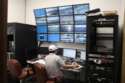
The command center at Pier 2 consists of nine 42-inch big screen monitors, with three more to be added, and comfortably holds 15-20 people. It is monitored 24/7 by a security guard company working for the harbor police and cultivates communication with all of the harbors and harbor police units. This hub has access to all of the cameras in the system and keeps in touch with all harbor operations. With the heavy influx of information, the center works through both the state’s internet and intranet networks.
The center’s computers run on Milestone XProtect Corporate, important for the diverse locations across the ocean dealing with unpredictable connections and varying system needs and conditions. A key function of the entire structure is that it meets the requirements for Title 33 of the Code of Federal Regulations, including a sub-section of these rules on navigating waters that are strategically in place to combat terrorism. Additionally, the system is helpful to traffic controllers to abide by safety requirements.
Adapting and Expanding
As some of the individual harbors are only serviced during working hours, additional surveillance units were needed to keep an eye on sites during off-peak hours. Hawaiya built mobile command centers, each consisting of two monitors and a server, to solve this issue. With a simple internet connection, these mobile centers can connect with all of the systems via the intranet and monitor on location for sporadic weather events and extenuating circumstances that call for added surveillance.
Though connectivity issues have risen in smaller spots like Port Allen Harbor in Kauai, Hawaiya has built out a combination of hot spots, DSL connections and other cable internet hookups to transfer and move data. With Anuenue in place, the state’s hardened microwave communication system; their primary goal is to optimize their own Maritime Wireless Network System. Operating across each island, it is being constructed to preserve a more hardened connection along with point-to-point microwave radios to connect the individual harbor and sensor sites to Anuenue. That state-led intranet structure stretches from the northernmost island of Hawaii to the southernmost and represents the backbone that carries all of the state’s information between the islands.
As with its past projects, Hawaiya selected 215 cameras across 18 harbors and critical infrastructure sites along with a selection of public properties, the distribution of the cameras varies from just a couple up to 15 at any individual location. Using point-to-point C band Proxim radios, the entirely IP-based system works to distribute surveillance to all locations on the islands, while stored centrally at Pier 2 in the Honolulu Harbor.
“The end goal is having all these very remote locations and so many areas able to be networked in the end and be deployed in so many different locations,” Chang added. “And it could not be done with the analog cameras.”
Video Surveillance Partner
Though the project started with AXIS Q6042 PTZ Dome Network Cameras almost exclusively, they shifted those offerings to the newer AXIS Q6044-E PTZ Dome Network Cameras for the HD-quality recording capabilities, along with a few AXIS Q6000-E PTZ Dome Network Cameras for 360-degree views. With multiple government entities requesting and using footage from the cameras, the HD-quality video is important in transferring the highest-caliber quality files without any resolution changes. 360-degree views helps to uphold efficiency in environments where a broad scene can be surveilled with a camera mounted from a high location that is able to compose an overarching perspective. To map out the selection of these cameras, Hawaiya utilized Axis system design tools to select the proper products for each unique environment.
“We have begun using the really outstanding tools that Axis has developed for planning and identifying the appropriate cameras to be used in any given area,” Paul Schultz, President and CEO of Hawaiya Technologies, Inc. noted. “It has been a significant help in planning some of our more complex installations.”
The purpose in selecting these cameras was to look at operations going on in the harbor areas, and the PTZ function allows them to have effective surveillance without hundreds of fixed cameras. They are being set up anywhere from 20 to 120 feet in the air, giving a widespread field of view. Many are set to perform periodic guard tours as well, scheduled scans of specific areas periodically.
At many of the critical infrastructure sites, Hawaiya installed fixed cameras instead, which not only provide them with outdoor-ready and vandal-resistant features, but also become very effective in varying lighting situations. The AXIS P3364-LVE Network Cameras are often paired with IR illuminators to deliver effective footage in low light. The AXIS P3364-LVEs also contain Axis’ Lightfinder technology that allows the video to maintain consistent color in poor lighting conditions.
“These are critical infrastructure sites that we don’t necessarily want to advertise how important they are,” Schultz said. “As soon as you put a high power illumination up, you’ve got this facility that’s lit up like a stadium out in the middle of nowhere and that would draw attention right away.”
With all of the weather and environment-related difficulties that arise being near heavy-trafficked ocean, such as powerful hurricanes and flash flooding, Hawaiya has seen significant durability in the cameras over long periods of time. “We have not had a single failure of an Axis camera that was caused by the marine environment, not a single failure,” Schultz added.
The Final Countdown
Looking to complete the fifth and final phase of the project by the end of 2015, Hawaiya is planning out the final steps to integrate all of the moving parts across the state. “We’ll have real time information on damage to the ports from hurricanes and storms,” noted Dolores Cook, Head of the Grants Management Office, Hawaii State DOD. “We’ll be able to tell you right away to move your ships and boats out of the way of the harbor. When we had the tsunami in 2011, we knew exactly where it was going to hit and how much the water was going to rise.”
These servers are already interacting with other Hawaiya set-ups in the state, including at multiple correctional centers. Working alongside the Oahu Community Correctional Center (OCCC), they have paired AXIS M7016 Video Encoders with old analog cameras in place in these situations. Using the AXIS P3364-LVEs whenever possible as well, they are taking advantage of Axis’ Corridor Format, which captures long hallways more effectively by flipping the aspect ratio from 16:9 to 9:16 for a vertical view.
Hawaiya is currently working with an attorney to coordinate policy interactions within the state and to map out the policies, procedures and protocols for each site, customizing to the needs of each station. Their goal is also to eventually get extra routers to link up each individual harbor to see one another over the state’s intranet, where all of the information and isolated systems could connect on the state network.
With the initial goal to invest in the long-term infrastructure of a comprehensive security and surveillance system, Hawaiya has continued to incorporate new technologies and upgrade the system’s architecture as time and conditions have permitted. The functional capabilities of such a thorough system were built to be scalable and expandable with hopes of incorporating statewide surveillance down the road. As a unique island territory dealing with rare environment and situational dilemmas not seen among any of the other 49 states, Hawaiya has specified unprecedented observation measures that will bring the state of Hawaii streamlined success for the foreseeable future.