Geospatial Awareness Could Be the Next Big Thing for VMS
Everything is going geospatial; from Twitter to Google, from Facebook to Pinterest. Although it may manifest itself under other names: location-based, geo-intelligence, GEOINT, map-based, geo-referencing, geo-analysis, these are all terms referring to the concept of geospatial, which is defined as relating to or denoting data that is associated with a particular location. It may sound very simple, but understanding different pieces of data at a particular location and time allows for a vast array of information that can aid users and system in all types of applications
In security terms, geospatial refers to WHAT happened, WHERE it happened and aids in helping understand the actions that should be taken. The use of geospatial data can be extremely powerful for security applications, and as such, it’s important for security professionals to understand how it can help make critical perimeters and facilities more secure.
Map-Based Presentation of Data
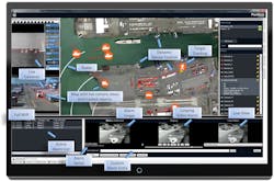
So what is a geospatial surveillance system and what value does it provide to a security provider? In a nutshell, a geospatial surveillance system is one that relies heavily on location data for primary display (e.g. a map-based user interface), threat analysis, sensor control and data collaboration. One of its advantages is that it provides a high level of situational awareness. Geospatial systems allow for a map-based representation of a system’s sensor location, sensor status and dynamic views of current security events. A user can view the graphical user interface (GUI) and quickly gain an understanding of the current state of events. This is in comparison to the more traditional systems, where a user, or multiple users, may have to check many monitors to understand the status of various sensors. This improvement in ease of use becomes increasingly important as the ability to hire and maintain security personnel becomes more difficult due to budget pressures and as the number of sensors in a security system increases.
This advantage of situational awareness is much the same as the use of a map when driving to a new location versus the use of a textual description of the same route. Although both have value, the map provides a frame of reference, instant visual cues and quickly communicates a large amount of detailed information. In this same manner, a geospatial user interface quickly conveys important situation information including physical location details, sensor locations, sensor coverage information, sensor type, target location, target track, target identification, target speed and detailed alarm information.
Geospatial Sensors
Key components of a geospatial surveillance system are the actual sensors that provide the detection and monitoring of data. When thinking about geospatial sensors, ones that understand inputs and outputs in terms of real space and time, there are several obvious ones that come to mind including radars, LIDARs and GPS sensors. These sensors provide a large amount of data including time-based location, speed and even acceleration.
A less obvious group of geospatial sensors are smartphones. It is typically understood that they contain a GPS, but they are often overlooked from a security standpoint. Smartphones in the hands of first responders can be a basis for coordinating assets to an event, as well as, using the smart phone’s camera capabilities to provide location-based images of events that can be documented and shared within the context of the geospatial surveillance system.
There are still other sensors that are “partially geospatial” or can be enabled to be geospatial. Fence and in-ground intrusion systems can provide an exact linear position along the fence, or at a minimum, identify a specific “zone” where the intrusion occurred. Cameras also fall into this category. Out of the box, they are not a geospatial sensor, but they can be enabled with this capability through a process called “geo-referencing.” This process involves a mapping between the camera field of view and a terrain map, allowing the camera to understand where each video pixel exists in latitude, longitude and elevation. Depending on the scene, just a few video-map pixel pairs are required for the software to extrapolate the mapping for the entire scene. This is true for both fixed cameras and pan-tilt-zoom cameras - even as they move away from the original scene.
A geospatially-enabled camera essentially acts as a short-range visual radar. Once a camera understands where a specific pixel resides in real space, it now has the ability to identify an object’s real size and real speed. Combining that with visual information, such as aspect ratio, compactness, color and texture, cameras can now classify objects in categories, such as, animal, person, car, truck, boat, aircraft, etc.
Still, other sensors can be considered “pseudo-geospatial.” These include sensors which have a physical location that has meaning to the security or operations manager. This would include sensors like access control systems, where the location of a specific door or gate has value. Other sensors that fall into this category are proximity sensors, RFID and safety sensors, such as equipment over heat, water detection or fire sensor.
Map-Based Sensor Control
In addition to being able to display sensor location, sensor state and target information on a map-based GUI, a geospatial system also provides for user interaction through this same interface. This means sensors can be queried and controlled by interaction with the map based display. Sensors typically used for event interrogation: PTZ cameras, laser illuminator, spotlights, range finders and acoustic devices, can also be enabled to be geospatial, allowing them to be monitored and controlled using latitude and longitude information. So, in addition to dynamically displaying the type of intrusion, the location and dynamic tracks, a geospatial system can use these same tracks as cues to point interrogation sensors directly to the location of the security event. Some sensors can then automatically follow the target as it moves within the scene. This ability to both monitor and react to situations in a map-based content makes these the interaction with these interfaces very intuitive and efficient for security personnel.
Sensor Collaboration
Another advantage of a geospatial surveillance system is the ease that sensors can share and collaborate on information. Geospatial sensors, or ones that have been enabled to be geospatial, share a common operating picture, mainly a physical coordinate system. This means they can effectively communicate with each other using a common geospatial command set. As a result, geospatial cameras do not need to understand radars’ range & bearing and a LRAD does not need to compute the linear reflection distance of a fence sensor. They exchange position information in terms of elevation, longitude and latitude. The ability to quickly take data from a large set of sensors and apply them to a particular target, or potential target, allows for much better alarm confidence, and reduction in nuisance alarms.
Track Fusion
A practical application of sensor collaboration can be seen in addressing a common issue of information clutter. With so many sensors in today’s security arsenal, it is not unusual to clutter a security person’s display with too much information. One form of clutter may involve tracks from multiple sensors, all indicating the same target. For example, both radar and video have the ability to provide real time map-based targets and when a single target passes through the detection area of both sensors, each sensor may each create a track for the same target, resulting in multiple tracks for the user to decipher.
To eliminate this issue, geospatial systems allow for what is referred to as “track fusion”. Track fusion is the means by which several sensors that have overlapping coverage areas collaborate track data, taking into account accuracy and update rates of each sensor, and then making the determination whether it is a single target, or multiple targets. The data from the various sensors is then merged to provide the user with a best case, single track and ID for that event.
If one of these targets is a GPS enabled asset belonging to the facility, such as a company vehicle or patrolling officer, the system can include the GPS in the merged track and automatically identify the object as a friend and avoid tripping any nuisance alarms as part of their regular patrols or actions. The system would denote the object as a “friend” through the use of an appropriate icon on the map and it would pass this information off to other sensors as the “friend” moves throughout the property. This capability is typically referred to as “IFF” or “Identify Friend or Foe.”
Automated Response
The use of geospatial data to aid in better identifying targets, displaying events and controlling sensors on its own is a valuable addition to any security system; however, these capabilities can all work to together and automate many tasks that previously required operator control. This now frees the operator to assess the situation and coordinate a response.
As an example, consider a very common intrusion at a perimeter, triggered by a fence sensor. Traditionally, such an alarm would require the security person to perform the following tasks:
- Understand the location of the event as announced by the fence alarm
- Determine the appropriate camera to interrogate the event’s validity
- Take control of the camera,
- Steer it to the point of intrusion, adjusting the pan, tilt and zoom
- Once the camera is viewing the event location, maneuver the camera to find the target that has likely moved,
- Confirm it is a real event; a human or vehicle versus an animal or debris
- Maintain control of the PTZ camera to monitor the continued movement of the target.
- Communicate the details of the event to fellow officers to take action
Through the use of geospatial capabilities just described; all these actions can be automated. The same event, when detected and responded to by a geospatial surveillance system, looks as follows:
- The intrusion is detected by a fence sensor, which communicates location to the geospatial surveillance system.
- The system automatically swings a PTZ camera to that location and triggers automatic camera following.
- Using a variety of attributes, including geospatial data, the system classifies the target (human, animal, vehicle) with a level of confidence, and if is meets the alarm objectives, provides a visual indication of the event.
- Understanding location and where the video image exists in map space, the system is then able to place the target on the map, including its target class and update its track in real time.
- Once the target is confirmed and being tracked, an LRAD is then automatically steered to the intruder to provide a deterrent message. The deterrent message can then be changed to increase its urgency based on the location, direction and speed of the intruder.
- The system then identifies the location of the nearest guard via their GPS enabled radio, assigns them the alarm, provides an alarm overview including image, video and location and
- Steers the officer toward the direction of the event to apprehend the intruder.
For much larger installations, the same type of geospatial system can provide expanded response capabilities, such as dispatching a drone to the exact location of an intrusion, finding the target and continuing to track until security personnel arrive; all achieved automatically through the sharing of geospatial / location data between the sensors and devices within the system.
Forensic Capability
Finally, the forensic value of a geospatial system cannot be overlooked. The ability to assign locations to events carries over into alarm searches and forensic efforts. Each alarm can be viewed at the location it occurred on the map. “Heat Maps” can also be created to show trends or anomalies. A geospatial GUI can also allow searches for alarms or activities based on an area of the map by simply selecting a region of interest. This can be extremely helpful when investigating specific incidents, or looking at alarm trends.
Geospatial surveillance systems are also the basis to perform a full map based, scenario replay. Essentially replaying everything that that operator was seeing on the screen, including alarms, sensor positions, map locations and what image was being viewed on a particular monitor. A replay of this nature is backed by real data, so at any point, the reviewer can drill down in the data to get the detailed data associated with the intruder or its track data.
Conclusion
“Everything happens somewhere” and today’s sensors and applications collect this data, track it and then share it with other sensors many times every second. This is true in our personal lives and is increasingly true in the security world. Today’s security professionals should seek to further understand the value geospatial sensors can provide and determine how best to incorporate that capability into security operations. In many cases, the current system may already include many of these sensors and it is only a matter of enabling their geospatial capabilities to allow them to provide value within the existing surveillance system.
About the author: Eric Olson is Vice President of Marketing at Phoenix-based video analytics developer PureTech Systems (www.puretechsystems.com). He can be contacted at [email protected] or via twitter @puretechsystems.